Quantcast
Channel: Marine Vessel Traffic
Viewing all 338 articles
Browse latest View live

Lurssen Wolgast

$
0
0
Newbuilt and Repair for yachts up to 175 Meter:
Shipyard Lurssen Wolgast - location, capacities, layout, docks, vessels under construction and repair. The Peene-Werft, located in Wolgast, belongs to the Ltirssen-Group since May 2013. This facility is specialized in new built and repairs of naval vessels and special ships, but is also supporting the yacht shipbuilding. The company area has a full size of 253.570 qm and 46.500 qm heated hall space, a dry dock with a crane of 175 meter length as well as a lift for ships up to 110m length and a 950 meter long outfitting quay.


SHIPYARDS LISTFIND A SHIPIMO / MMSI SEARCHSEA DISTANCE CALCULATOR
Remark: This Live Tracking AIS Vessel Finder map shows vessels' location any time but if ship is out of range or with a switch off AIS transmitter then it would be the last known position.

Lurssen Wolgast

LEGEND: 1. Dry Dock - 175 x 29.3 m; 2. Warehouse; 3. Shipbuilding Shed - 94 x 30 m; 4. Prefabrication Shed / Section building - length: 68 to 120 m, beam: 108 m; 5. Prefabrication Shed - 120 x 48 m; 6. Prefabrication / Outfitting Shed - 4 sheds of length: 124 - 174 m, beam: 18 m; 7. Marine center - 124 x 26 m; 8. Lift - 110 x 15 m, lifting force: 4000 t;

Vessel Traffic

$
0
0

 
  *Note: If map is zoomed in large scale (closer to earth surface) ship names appear in "HIDE" mode as well.


   GO TO AREA LIVE TRACKING :  


Vessel Finder Map Legend

A vessel traffic service (VTS) is a marine traffic monitoring system established by harbour or port authorities, similar to air traffic control for aircraft. Typical VTS systems use radar, closed-circuit television (CCTV), VHF radiotelephony and automatic identification system to keep track of vessel movements and provide navigational safety in a limited geographical area.

Vessel Traffic Services:
A service implemented by a competent authority, VTS is designed to improve the safety and efficiency of navigation, safety of life at sea and the protection of the marine environment. VTS is governed by SOLAS Chapter V Regulation 12 together with the Guidelines for Vessel Traffic Services [IMO Resolution A.857(20)] adopted by the International Maritime Organization on 27 November 1997.

The VTS traffic image is compiled and collected by means of advanced sensors such as radar, AIS, direction finding, CCTV and VHF or other co-operative systems and services. A modern VTS integrates all of the information into a single operator working environment for ease of use and in order to allow for effective traffic organization and communication.

The image shows a typical state-of-the-art integrated operator working position. In areas that are covered with VTS there are certain procedures for vessels to follow such as Area Procedures, Sector Areas, Arrival and Departure Reports, Approach Procedures, Pilotage Procedures and many more. Each of the above procedures are named with respect to the area that they serve. For example in Norway, Oslofjord the Area Procedures are called "OSL1" and "OSL3" and in Netherlands, Rotterdam, Maas Approach and Maas Entrance are called "RTM2" and "RTM6" respectively.

A VTS should always have a comprehensive traffic image, which means that all factors influencing the traffic as well as information about all participating vessels and their intentions should be readily available. By means of the traffic image, situations that are developing can be evaluated and responded upon. The data evaluation depends to a great extent on the quality of the data that is collected and the ability of the operator to combine this with an actual or developing situation. The data dissemination process exists of conveying the conclusions of the operator.

Text is available under the Creative Commons Attribution-Share Alike License. Read License Terms at the following web address: creativecommons.org/licenses/by-sa/3.0/

Marine Vessel

$
0
0

 
  *Note: If map is zoomed in large scale (closer to earth surface) ship names appear in "HIDE" mode as well.


   GO TO AREA LIVE TRACKING :  


Vessel Finder Map Legend


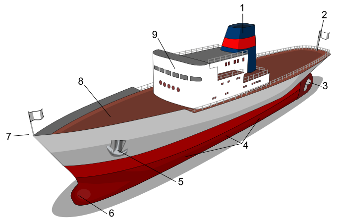
Main Parts of Ship:
Main parts of ship. 1: Smokestack or Funnel; 2: Stern; 3: Propeller and Rudder; 4: Portside (the right side is known as starboard); 5: Anchor; 6: Bulbous bow; 7: Bow; 8: Deck; 9: Superstructure


Ship Construction
Main Parts of Ships

The Naval Architect:
Due to the complexity associated with operating in a marine environment, naval architecture is a co-operative effort between groups of technically skilled individuals who are specialists in particular fields, often coordinated by a lead naval architect. This inherent complexity also means that the analytical tools available are much less evolved than those for designing aircraft, cars and even spacecraft. This is due primarily to the paucity of data on the environment the marine vehicle is required to work in and the complexity of the interaction of waves and wind on a marine structure.

A naval architect is an engineer who is responsible for the design, construction, and/or repair of ships, boats, other marine vessels, and offshore structures, both commercial and military, including:


  • Merchant ships – oil tankers, gas tankers, cargo ships, bulk carriers, container ships
  • Passenger/vehicle ferries, cruise ships
  • Warships – frigates, destroyers, aircraft carriers, amphibious ships
  • Submarines and underwater vehicles
  • Icebreakers
  • High speed craft – hovercraft, multi-hull ships, hydrofoil craft
  • Workboats – barges, fishing boats, anchor handling tug supply vessels, platform supply vessels, tug boats, pilot vessels, rescue craft
  • Yachts, power boats, and other recreational watercraft
  • Offshore platforms and subsea developments


Some of these vessels are amongst the largest (such as supertankers), most complex (such as Aircraft carriers), and highly valued movable structures produced by mankind. They are typically the most efficient method of transporting the world's raw materials and products. Modern engineering on this scale is essentially a team activity conducted by specialists in their respective fields and disciplines. Naval architects integrate these activities. This demanding leadership role requires managerial qualities and the ability to bring together the often-conflicting demands of the various design constraints to produce a product which is fit for the purpose.

In addition to this leadership role, a naval architect also has a specialist function in ensuring that a safe, economic, environmentally sound and seaworthy design is produced. To undertake all these tasks, a naval architect must have an understanding of many branches of engineering and must be in the forefront of high technology areas. He or she must be able to effectively utilize the services provided by scientists, lawyers, accountants, and business people of many kinds.

Naval architects typically work for shipyards, ship owners, design firms and consultancies, equipment manufacturers, Classification societies, regulatory bodies (Admiralty law), navies, and governments.

Text is available under the Creative Commons Attribution-Share Alike License. Read License Terms at the following web address: creativecommons.org/licenses/by-sa/3.0/

CONTAINER SHIPS AND CARGO TRACKING

$
0
0


LogoContainer Line NameShips TrackingContainer TrackingShips Schedules
Maersk Logo
MAERSK
"MAERSK" Ships Tracking
"MAERSK" Container Tracking
Schedules of "MAERSK"
MSC Logo
MSC
"MSC" Ships Tracking
"MSC" Container TrackingSchedules of "MSC"
CMA CGM Logo
CMA CGM
"CMA CGM" Ships Tracking
"CMA CGM" Container TrackingSchedules of "CMA CGM"
Evergreen Line Logo
EVERGREEN
"EVERGREEN" Ships Tracking
"EVERGREEN" Container TrackingSchedules of "EVERGREEN"
COSCO Line Logo
COSCO
"COSCO" Ships Tracking
"COSCO" Container TrackingSchedules of "COSCO"
HAPAG LLOYD Logo
HAPAG-LLOYD
"HAPAG-LLOYD" Ships Tracking
"HAPAG LLOYD" Container TrackingSchedules of "HAPAG LLOYD"
APL Logo
APL
"AMERICAN PRESIDENT LINES" Ships Tracking
"APL" Container TrackingSchedules of "APL"
HANJIN Logo
HANJIN
"HANJIN" Ships Tracking
"HANJIN" Container TrackingSchedules of "HANJIN"
CSCL Logo
CSCL
"CSCL" Ships Tracking
"CSCL" Container TrackingSchedules of "CSCL"
MOL Logo
MOL
"MOL" Ships Tracking
"MOL" Container TrackingSchedules of "MOL"
Hamburg Sud Logo
HAMBURG SÜD
"HAMBURG SUD" Ships Tracking
"HAMBURG SUD" Container TrackingSchedules of "HAMBURG SUD"
NYK Logo
NYK
"NYK" Ships Tracking
"NYK" Container TrackingSchedules of "NYK"
OOCL Logo
OOCL
"OOCL" Ships Tracking
"OOCL" Container TrackingSchedules of "OOCL"
Yang Ming Logo
YANG MING
"YANG MING" Ships Tracking
"YANG MING" Container TrackingSchedules of "YANG MING"

Page 1 of 7 | Go to Page: 1|2|3|4|5|6|7

Container ships are cargo ships that carry all of their load in truck-size intermodal containers, in a technique called containerization. They are a common means of commercial intermodal freight transport and now carry most seagoing non-bulk cargo. Container ship capacity is measured in twenty-foot equivalent units (TEU). Typical loads are a mix of 20-foot and 40-foot (2-TEU) ISO-standard containers, with the latter predominant. Container ships are distinguished into 7 major size categories: small feeder, feeder, feedermax, panamax, post-panamax, new panamax and ultra-large. As of December 2012, there are 161 container ships in the VLCS class (Very Large Container Ships, more than 10,000 TEU), and 51 ports in the world can accommodate them.

Container Ships Current Position Tracking
Preview of Container Ships Current Position Dual Tracking
Container number explained
CONTAINER NUMBER EXPLAINED
Reamark: This image is provided by Wikipedia under Creative Commons Attribution-ShareAlike 4.0 International Public License

The size of a panamax vessel is limited by the Panama canal's lock chambers, which can accommodate ships with a beam of up to 32.31 m, a length overall of up to 294.13 m, and a draft of up to 12.04 m. The "post panamax" category has historically been used to describe ships with a moulded breadth over 32.31 m, however the Panama Canal expansion project is causing some changes in terminology. The "new panamax" category is based on the maximum vessel-size that will be able to transit a new third set of locks. The new locks are being built to accommodate a container ship with a length overall of 366 metres (1,201 ft), a maximum width of 49 metres (161 ft), and tropical fresh-water draft of 15.2 metres (50 ft). Such a vessel would be wide enough to carry 19 rows of containers, have a total capacity of approximately 12,000 TEU and be comparable in size to a capesize bulk carrier or a suezmax tanker. Container ships under 3,000 TEU are generally called feeders. Feeders are small ships that typically operate between smaller container ports. Some feeders collect their cargo from small ports, drop it off at large ports for transshipment on larger ships, and distribute containers from the large port to smaller regional ports. This size of vessel is the most likely to carry cargo cranes on board.

SHIPS & CARGO TRACKING

IMPA Code Search

$
0
0

Search by IMPA number and text description on the following web address:
www.shipserv.com/impaweb/search_impa_item.do

IMPA Catalogue
IMPA Catalogue 6th Edition / 2013

On-line search of IMPA items from the latest edition.
The ultimate mariner's book of codes for ordering various ship stores from ship supply companies (ship chandlers).

MAERSK INDUS CURRENT POSITION - DUAL TRACKING

$
0
0
Current Position of MAERSK INDUS, Present and Out of Range Last Known Location, Next Port of Call, ETA, IMO, Speed, Track, Flag


CURRENT POSITION MAP - MARINE TRAFFICCURRENT POSITION MAP - VESSEL FINDER
ALL CONTAINER LINESMAERSK SHIPS TRACKINGWeather MapBunker Prices
Remark: These Live Tracking AIS maps show vessel's location any time but if ship is out of range it would be the last known position.

MAERSK EUPHRATES CURRENT POSITION - DUAL TRACKING

$
0
0
Current Position of MAERSK EUPHRATES, Present and Out of Range Last Known Location, Next Port of Call, ETA, IMO, Speed, Track, Flag


CURRENT POSITION MAP - MARINE TRAFFICCURRENT POSITION MAP - VESSEL FINDER
ALL CONTAINER LINESMAERSK SHIPS TRACKINGWeather MapBunker Prices
Remark: These Live Tracking AIS maps show vessel's location any time but if ship is out of range it would be the last known position.

KAETHE P CURRENT POSITION - DUAL TRACKING

$
0
0
Current Position of KAETHE P, Present and Out of Range Last Known Location, Next Port of Call, ETA, IMO, Speed, Track, Flag


CURRENT POSITION MAP - MARINE TRAFFICCURRENT POSITION MAP - VESSEL FINDER
ALL CONTAINER LINESMAERSK SHIPS TRACKINGWeather MapBunker Prices
Remark: These Live Tracking AIS maps show vessel's location any time but if ship is out of range it would be the last known position.

HAN JI 2 CURRENT POSITION - DUAL TRACKING

$
0
0
Current Position of HAN JI 2, Present and Out of Range Last Known Location, Next Port of Call, ETA, IMO, Speed, Track, Flag


CURRENT POSITION MAP - MARINE TRAFFICCURRENT POSITION MAP - VESSEL FINDER
ALL CONTAINER LINESMAERSK SHIPS TRACKINGWeather MapBunker Prices
Remark: These Live Tracking AIS maps show vessel's location any time but if ship is out of range it would be the last known position.

MCC PALAWAN CURRENT POSITION - DUAL TRACKING

$
0
0
Current Position of MCC PALAWAN, Present and Out of Range Last Known Location, Next Port of Call, ETA, IMO, Speed, Track, Flag


CURRENT POSITION MAP - MARINE TRAFFICCURRENT POSITION MAP - VESSEL FINDER
ALL CONTAINER LINESMAERSK SHIPS TRACKINGWeather MapBunker Prices
Remark: These Live Tracking AIS maps show vessel's location any time but if ship is out of range it would be the last known position.

SANTA LAURA CURRENT POSITION - DUAL TRACKING

$
0
0
Current Position of SANTA LAURA, Present and Out of Range Last Known Location, Next Port of Call, ETA, IMO, Speed, Track, Flag


CURRENT POSITION MAP - MARINE TRAFFICCURRENT POSITION MAP - VESSEL FINDER
ALL CONTAINER LINESMAERSK SHIPS TRACKINGWeather MapBunker Prices
Remark: These Live Tracking AIS maps show vessel's location any time but if ship is out of range it would be the last known position.

LADY GLORIA CURRENT POSITION - DUAL TRACKING

$
0
0
Current Position of LADY GLORIA, Present and Out of Range Last Known Location, Next Port of Call, ETA, IMO, Speed, Track, Flag


CURRENT POSITION MAP - MARINE TRAFFICCURRENT POSITION MAP - VESSEL FINDER
ALL CONTAINER LINESMAERSK SHIPS TRACKINGWeather MapBunker Prices
Remark: These Live Tracking AIS maps show vessel's location any time but if ship is out of range it would be the last known position.

MSC AMY CURRENT POSITION - DUAL TRACKING

$
0
0
Current Position of MSC AMY, Present and Out of Range Last Known Location, Next Port of Call, ETA, IMO, Speed, Track, Flag


CURRENT POSITION MAP - MARINE TRAFFICCURRENT POSITION MAP - VESSEL FINDER
ALL CONTAINER LINESMAERSK SHIPS TRACKINGWeather MapBunker Prices
Remark: These Live Tracking AIS maps show vessel's location any time but if ship is out of range it would be the last known position.

VIKTORIA WULFF CURRENT POSITION - DUAL TRACKING

$
0
0
Current Position of VIKTORIA WULFF, Present and Out of Range Last Known Location, Next Port of Call, ETA, IMO, Speed, Track, Flag


CURRENT POSITION MAP - MARINE TRAFFICCURRENT POSITION MAP - VESSEL FINDER
ALL CONTAINER LINESMSC SHIPS TRACKINGWeather MapBunker Prices
Remark: These Live Tracking AIS maps show vessel's location any time but if ship is out of range it would be the last known position.

CMA CGM LOIRE CURRENT POSITION - DUAL TRACKING

$
0
0
Current Position of CMA CGM LOIRE, Present and Out of Range Last Known Location, Next Port of Call, ETA, IMO, Speed, Track, Flag


CURRENT POSITION MAP - MARINE TRAFFICCURRENT POSITION MAP - VESSEL FINDER
ALL CONTAINER LINESCMA CGM SHIPS TRACKINGWeather MapBunker Prices
Remark: These Live Tracking AIS maps show vessel's location any time but if ship is out of range it would be the last known position.

MSC NINGBO CURRENT POSITION - DUAL TRACKING

$
0
0
Current Position of MSC NINGBO, Present and Out of Range Last Known Location, Next Port of Call, ETA, IMO, Speed, Track, Flag


CURRENT POSITION MAP - MARINE TRAFFICCURRENT POSITION MAP - VESSEL FINDER
ALL CONTAINER LINESCOSCO SHIPS TRACKINGWeather MapBunker Prices
Remark: These Live Tracking AIS maps show vessel's location any time but if ship is out of range it would be the last known position.

NORTHERN JULIE CURRENT POSITION - DUAL TRACKING

$
0
0
Current Position of NORTHERN JULIE, Present and Out of Range Last Known Location, Next Port of Call, ETA, IMO, Speed, Track, Flag


CURRENT POSITION MAP - MARINE TRAFFICCURRENT POSITION MAP - VESSEL FINDER
ALL CONTAINER LINESHAPAG-LLOYD SHIPS TRACKINGWeather MapBunker Prices
Remark: These Live Tracking AIS maps show vessel's location any time but if ship is out of range it would be the last known position.

ANTON SCHULTE CURRENT POSITION - DUAL TRACKING

$
0
0
Current Position of ANTON SCHULTE, Present and Out of Range Last Known Location, Next Port of Call, ETA, IMO, Speed, Track, Flag


CURRENT POSITION MAP - MARINE TRAFFICCURRENT POSITION MAP - VESSEL FINDER
ALL CONTAINER LINESAPL LINE SHIPS TRACKINGWeather MapBunker Prices
Remark: These Live Tracking AIS maps show vessel's location any time but if ship is out of range it would be the last known position.

SEROJA LIMA CURRENT POSITION - DUAL TRACKING

$
0
0
Current Position of SEROJA LIMA, Present and Out of Range Last Known Location, Next Port of Call, ETA, IMO, Speed, Track, Flag


CURRENT POSITION MAP - MARINE TRAFFICCURRENT POSITION MAP - VESSEL FINDER
ALL CONTAINER LINESAPL LINE SHIPS TRACKINGWeather MapBunker Prices
Remark: These Live Tracking AIS maps show vessel's location any time but if ship is out of range it would be the last known position.
Viewing all 338 articles
Browse latest View live